|
Lassen Volcanic National Park:
Lassen Peak and Chaos Crags |
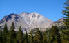
| Lassen Volcanic
National Park was established soon
after the eruption of Lassen Peak
from 1914-17. The park contains a
wealth of volcanic features and
landforms, including plug domes,
small basaltic shields, cinder
cones, and geothermal features.
Brokeoff Mountain is part of Mt.
Tehama, a stratovolcano that eroded
away several hundred thousand years
ago. Lassen Peak, which first
erupted about 27,000 years ago, is
likely the largest plug dome in the
world. Nearby Chaos Crags are a
series of seven lava domes that
erupted only a thousand years ago. |
 |
 |
 |
 |
 |
 |
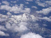
| Aerial view
of Lassen Peak |
Aerial view
of Lassen Peak |
Aerial view
of Lassen Peak |
Aerial view
of Lassen Peak |
Aerial view
of Lassen Peak and Brokeoff Mountain |
Aerial view
of Lassen Peak and Brokeoff Mountain |
 |
 |
 |
 |
 |
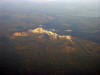 |
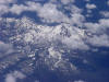
| Aerial view
of Lassen Peak with Chaos Crags on
left, Brokeoff Mtn on right |
Aerial view
of Lassen Peak with Chaos Crags on
right |
Aerial view
of Lassen Peak with Brokeoff Mtn on
right |
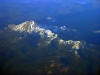
Aerial view
of Lassen Peak with Chaos Crags on
left, Brokeoff Mtn on right |
Aerial view
of Lassen Peak with Chaos Crags on
left, Brokeoff Mtn on right
(labeled) |
Aerial view
of Lassen Peak with Chaos Crags on
left, Brokeoff Mtn on right |
 |
 |
 |
 |
 |
 |
| Aerial view
of Lassen Peak with Brokeoff Mtn on
right |
Aerial view
of Lassen Peak with Brokeoff Mtn on
right |
Aerial view
of Lassen Peak with Brokeoff Mtn on
right |
Lassen Peak
from the north, at the Devastated
Area |
Lassen Peak
from the north, at the Devastated
Area, zooming on summit area |
Lassen Peak
from the north, at the Devastated
Area, zooming on summit area |
 |
 |
 |
 |
 |
 |
| I didn't
take this! NPS photo of Lassen
erupting in 1914 - photo by B.F.
Loomis |
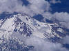
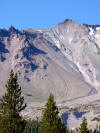
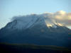
Lassen Peak
from the south, near the Bumpass
Hell trail, fall 2009 |
Lassen Peak
from the south, near the Bumpass
Hell trail |
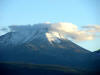
Lassen Peak
from the south, near the Bumpass
Hell trail and Lake Helen |
Lassen Peak
from the south, near the Bumpass
Hell trail and Lake Helen |
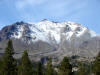
Lassen Peak
from the south, near the Bumpass
Hell trail |
 |
 |
 |
 |
 |
 |
| Lassen Peak
from the south, near the Bumpass
Hell trail |
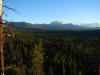
Lassen Peak
and Chaos Crags from the Hat Creek
area. Both mountains are plug domes |
Chaos Crags
from the Hat Creek area |
Lassen Peak
from the Hat Creek area in Fall 2007 |
Lassen Peak
from Hat Creek area |
Lassen Peak
from Hat Creek area |
 |
 |
 |
 |
 |
 |
| Lassen Peak
and Chaos Crags from Hat Creek area
in Fall 2007 |
Lassen Peak
from Devastated Area in Fall 2007 |
Lassen Peak
from Devastated Area with early Fall
snow |
Vulcans Eye
from the Lassen Peak Trail |
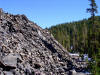
Chaos Crags
and Chaos Jumbles at Lassen Volcanic
National Park. |
Lassen Peak
and Helen Lake, Fall 2005 |
 |
 |
|
|
|
|
| Lassen Peak
from the south, Fall 2005 |
Chaos Crags
near Lassen Peak, a series of plug
domes erupted about 1,000 years ago |
|
|
|
|
 |
 |
 |
 |
 |
|
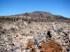
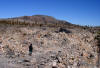
| Glass
Mountain is a very young plug dome
composed of obsidian and pumice |
Glass
Mountain, on the flank of Medicine
Lake Highland, is only about 1,000
years old |
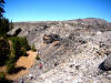
Edge of
Glass Mountain flow, mostly rhyolite
pumice and obsidian |
Glass
Mountain plug dome on Medicine Lake
Highland |
Coulee of
Glass Mountain flow on side of
Medicine Lake Highland |
|
 |
 |
 |
 |
|
|
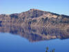
| Llao Rock, a
former plug dome on rim of Crater
Lake |
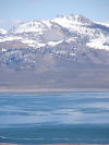
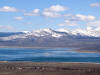
Mono Craters
and Mono Lake in the Eastern Sierra
Nevada. |
The Mono
Craters range in age from 600 to
about 35,000 years |
The Mono
Craters are one of the most
volcanically active areas in
California |
|
|
 |
 |
 |
|
|
|
| Black Butte
(6,334 ft) is a plug dome on the
west flank of Mt. Shasta |
Black Butte
near Mt. Shasta erupted between
9,000 and 10,000 years ago |
Black Butte
is near Mt. Shasta is easily visible
from Interstate 5. These views are
from the Everitt Highway |
|
|
|
| |
|
|
|
|
|
 |
|
|
|
|
|


