|
The San Andreas Fault System of California |
|
The San Andreas fault runs for some
600 miles across California from the
Salton Sea region to the north coast
beyond Mendocino. It is responsible
for two of California's three
largest recorded earthquakes, and
has produced large earthquakes every
century or so for at least the last
5,000 years. It began moving about
29 million years ago, and has
shifted parts of the state a minimum
of 195 miles (and possibly much
more). It passes close to or through
a number of urban areas, including
San Francisco, San Bernardino,
Palmdale and Palm Springs. It is a
right lateral strike-slip
fault. |
 |
 |
 |
 |
 |
 |
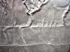
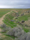
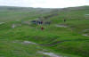
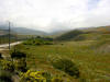
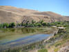
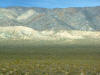
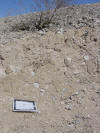
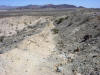
| Offset
stream along San Andreas fault in
Carrizo Plains National Monument, CA
(picture is mine, but of someone
else's poster) |
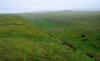
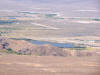
Surface view
of offset stream shown in previous
photo. San Andreas fault in Carrizo
Plains National Monument |
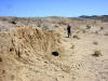
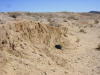
Small
graben (enclosed basin) along the
San Andreas fault in Carrizo Plains
National Monument. |
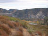
Looking at a
small graben developed along the San
Andreas at Carrizo Plains National
Monument |
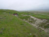
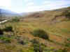
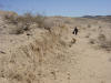
A small
offset channel on the San Andreas in
Carrizo Plains National Monument |
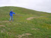
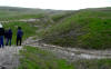
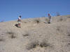
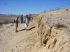
Students
walk on the plate boundary between
the Pacific and North American
plates. Carrizo Plains National
Monument |
 |
 |
 |
 |
 |
 |
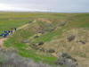
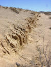
| Offset
Stream at Wallace Creek on the San
Andreas fault in Carrizo Plains
National Monument |
Offset
Stream at Wallace Creek on the San
Andreas fault in Carrizo Plains
National Monument |
Offset
Stream at Wallace Creek on the San
Andreas fault in Carrizo Plains
National Monument |
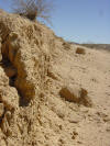
Fault scarp
at Wallace Creek on the San Andreas
fault in Carrizo Plains National
Monument |
Terrace and
scarp on the San Andreas fault in
Carrizo Plains National Monument |
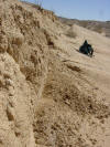
Unstable
slopes on the San Andreas fault in
Carrizo Plains National Monument |
 |
 |
 |
 |
 |
 |
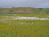
| Small sag
pond on the San Andreas fault in
Carrizo Plains National Monument |
Offset
stream and shutter ridge on San
Andreas fault on the Carrizo Plains |
Offset
stream on the San Andreas fault in
Carrizo Plains National Monument |
Offset
stream on the San Andreas fault in
Carrizo Plains National Monument |
Offset
stream and terrace on the San
Andreas fault in Carrizo Plains
National Monument |
Offset
stream on the San Andreas fault in
Carrizo Plains National Monument |
 |
 |
 |
 |
 |
 |
| Shutter
Ridge on the San Andreas fault in
Carrizo Plains National Monument |
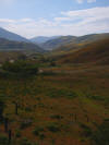
Lone Pine
Canyon in Southern California is a
dramatic example of a linear valley
along the San Andreas fault |
Lone Pine
Canyon in Southern California is a
dramatic example of a linear valley
along the San Andreas fault |
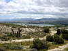
The San
Andreas fault is exposed in the Blue
Cut of lower Cajon Pass. Lost Lake
is a small sag pond. Foreground
slope is a scarp |
At Cajon
Pass in Southern California, the San
Andreas forms a sag pond (Lost Lake)
and a prominent scarp |
Lost Lake, a
sag pond on the San Andreas fault in
the Cajon Pass area of southern
California |
 |
 |
 |
|
 |
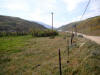 |
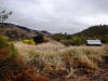
| Linear
valley and depressions along San
Andreas near Gorman and Interstate-5 |
Linear
valley and depressions along San
Andreas near Gorman and Interstate-5 |
Linear
valley and depressions along San
Andreas near Gorman and Interstate-5 |
Linear
valley and depressions along San
Andreas near Gorman and I-5 |
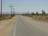
Trees mark
approximate location of San Andreas
at Gorman, CA |
Trees and
linear valley mark approximate
location of San Andreas at Gorman,
CA |
 |
 |
 |
 |
 |
 |
| Highly
deformed sediments in shutter ridge
bisected by Highway 14 in Palmdale. |
Palmdale
Reservoir is a 'former' sag pond on
the San Andreas fault modified by
the dam |
Trees and
linear valley mark approximate
location of San Andreas at Gorman,
CA |
Sag pond on
the San Andreas fault near Gorman CA
near Interstate 5 |
Gratuitous
flower scene on slopes above San
Andreas fault at Gorman, CA |
Lupines and
linear valley mark approximate
location of San Andreas at Gorman,
CA |
 |
 |
 |
 |
 |
 |
| Sag pond on
San Andreas fault near Gorman CA |
Sag pond on
San Andreas fault near Gorman CA |
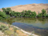
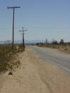
Offset
drainage culvert at DeRose Winery on
San Andreas fault near Hollister in
2013 |
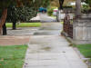
Offset
retaining wall in Hollister CA on
Calaveras fault (creeping section) |
Offset wall
in Hollister CA on Calaveras fault
(creeping section) |
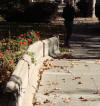
Offset
sidewalk in Hollister CA on
Calaveras fault (creeping section) |
 |
 |
 |
 |
|
|
| Shutter
ridge on San Andreas fault south of
Hollister |
Offset
culvert at De Rose Winery south of
Hollister CA on San Andreas fault in
2011 |
Interior
damage at De Rose Winery on San
Andreas fault in 2011 |
Offset
retaining wall in Hollister on
Calaveras fault in 2010 |
|
|
| |
|
|
|
|
|
| |
|
|
|
|
|
| |
|
|
|
|
|
| |
|
|
|
|
|
|
Other Strike-slip faults in
California |
|
|
 |
 |
 |
 |
 |
 |
| Shutter
ridge on Garlock fault in the Mojave
Desert. The light colored ridge has
deflected streams coming out of the
mountains |
Shutter
ridges form when one side of a
strike-slip fault moves to block
stream drainages. The Garlock is a
left later fault with 40 miles of
offset |
A shutter
ridge crosses the floor of Death
Valley near the Mesquite Dunes north
of Furnace Creek. It deflects
drainages on the alluvial fan
complex |
A cinder
cone in the southern part of Death
Valley has been offset in a
right-lateral sense. |
Diaz Lake
near Lone Pine, CA is a sag pond
formed by lateral movements during
the 1872 Lone Pine earthquake (mag.
7.8 or so) |
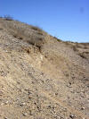
Scarp on
section of Landers fault, Mojave
Desert, from the
1992 Landers earthquake.
Movement was mainly lateral, but
shifted ridges, forming the
prominent scarps. |
 |
 |
 |
 |
 |
 |
| Offset
telephone pole where Landers fault
crosses road.
The 1992 Landers quake was mag
7.3 |
Reche Road
near Landers was offset by the 1992
quake, and repairs left the road
offset in a right later sense |
A low scarp
called a mole track on the Landers
fault following the
1992 quake |
Scarp from
the 1992 Landers earthquake on
hillside in the Mojave Desert, taken
in 2003 |
Person for
scale on low scarp from the 1992
Landers earthquake in the Mojave
Desert |
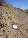
Measuring a
small offset drainage on the Landers
fault scarp showing about 10 feet of
right lateral movement |
 |
 |
 |
 |
 |
 |
| Scarp from
the 1992 Landers earthquake in the
Mojave Desert. Movement was lateral,
and shifted a ridge out of place |
Face of the
scarp from the
1992 Landers earthquake, after
11 years |
Erosion of
scarp from the
1992 Landers earthquake, after
11 years (picture taken in 2003) |
Vertical
scarp formed during the
1992 Landers earthquake, after
eleven years of desert erosion |
Vertical
scarp formed during the
1992 Landers earthquake, after
eleven years of desert erosion |
Vertical
scarp formed during the
1992 Landers earthquake, after
eleven years of desert erosion |
 |
 |
 |
 |
 |
 |
| Vertical
scarp formed during the
1992 Landers earthquake, after
eleven years of desert erosion |
Vertical
scarp formed during the
1992 Landers earthquake, after
eleven years of desert erosion |
Detail of
vertical scarp formed during the
1992 Landers earthquake, after
eleven years of desert erosion |
Vertical
scarp formed during the
1992 Landers earthquake, after
eleven years of desert erosion |
Vertical
scarp formed during the
1992 Landers earthquake, after
eleven years of desert erosion |
Vertical
scarp formed during the
1992 Landers earthquake, after
eleven years of desert erosion |
 |
|
|
|
|
|
| Scarp from
the 1992 Landers earthquake in the
Mojave Desert |
|
|
|
|
|

