|
|
File name |
Description |
 |
Lugano Lake |
Early in the day we passed through
Milan, and started up the long
Levantina Valley. We passed several
beautiful resort lakes, including
Como, and the one seen here, Lake
Lugano.
|
 |
Lugano Lake |
Like Garda, Lugano and the other
lakes were shaped and deepened by
the four glacial ice ages that
effected this region. With the
southern sun exposure, the climate
of the lakes is much warmer than
other parts of the Alps, and these
lakes are favorite vacation
destinations for Italians and
northern Europeans alike.
|
 |
Peaks in the clouds at Bellinzona |
We crossed the frontier into
Switzerland long before we reached
the pass. Switzerland actually
extends over the Alps, and far into
the drainage of the upper Po River
upstream of Italy. Many of the
residents in the area are culturally
and linguistically Italian. We
stopped for lunch at a roadside rest
in a village called Bellinzona.
|
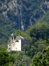 |
Monastery near Bellinzano |
Beautiful hanging valleys revealed
waterfalls, which formed as the main
trunk glacier cut a deeper valley
than the branch glaciers. Scenic
towers and monasteries were present
throughout the region. This was
probably near Monte Carasso. |
 |
Bellinzano |
Below the rest area there was a
flower bedecked meadow next to the
river. It was one of the coolest,
greenest places we had yet seen
during this hot July journey! |
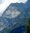 |
Limestone cliffs |
As we drove further up the valley,
huge outcrops of limestone became
visible...these were once deposits
on the floor of the Tethys Sea, a
forerunner to the Mediterranean Sea
that was destroyed when the African
plate crashed into the southern
European plate. |
 |
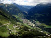
Upper Levantina Valley |
As we approached the head of the
Valle Levantina, the mountains along
the high crest of the Alps came into
view. Some of the peaks here
approach elevations exceeding 3,000
meters. Our road can be seen
switchbacking up the mountain in the
center of the picture.
|
 |
Upper Levantina Valley |
The shape of the mountains here is
more angular. Instead of being
scoured by the passage of glaciers,
these peaks were the source of the
glaciers, and were never covered.
The glaciers pluck rocks from the
sides and edges, forming cliffs,
aretes, and horns. No active
glaciers are in evidence here...the
site was chosen for travel because
it was lower, and ice-free during
the summer. A few tens of miles to
the west, at the Jungfrau, the peaks
exceed 4,000 meters, and are mantled
with glaciers that are many miles
long.
|
 |
Upper Levantina Valley |
This is not to say that it doesn't
snow at these elevations. The long,
glacially-steepened valleys are
under the constant danger of
avalanches. These structures are
designed to increase the stability
of snow banks on these high ridges. |
 |
Approaching St. Gotthard Pass |
St. Gotthard Pass first opened for
travel in the 12th century, with the
completion of a bridge over a
particularly rugged gorge on the
north side. A railway tunnel
circumvented the pass in 1882, and
in 1980, a 10.5 mile long automobile
tunnel was opened. This was the
third longest of its type in the
world at the time. A railway tunnel
currently under construction will be
35 miles long, and will be the
longest in the world. |
 |
Approaching St. Gotthard Pass |
Two paved roads still cross the
pass, an older cobblestone pathway
(visible in the previous photo), and
a more modern highway. It is an
important alternative when the
tunnel is closed for various reasons
(a truck collision and explosion in
2001 killed eleven people). Our bus
driver was kind enough to take us
over the pass, and we enjoyed an
spectacular view of the Valle
Levantina (and a view of a few
thousand feet straight down under
the highway!).
|
 |
The View from St. Gotthard Pass |
We stopped at a lookout point near
the summit of the pass and explored
for a few minutes, taking in a
glorious view. Looking south over
the Valle Levantina, we could see
the long u-shaped valley left behind
by the glaciers. |
 |
The View from St. Gotthard Pass |
The slightly wider view shown here
includes the village of Airolo,
where the railway and auto tunnels
disappear into the mountain |
 |
The View from St. Gotthard Pass |
Looking further to the east. The
roof over the highway is an
avalanche shelter. |
 |
Gneiss |
The rocks that make up the highest
part of the Alps are composed of
highly metamorphosed rocks, brought
up from deep in the crust during the
collision of Africa and Europe.
These were a sharp contrast to the
limestones and shales that we saw in
the Apennines. |
 |
The Rock Shop! |
What a great place for a rock shop!
Although I have to admit, it was
hard taking precious minutes from
the view to see what they have for
sale. But the sign was pretty cool
to see! |
 |
Near the top of the Alps! |
The summit of the pass lies at an
elevation of
2,108m
(6,916
ft). Your
webmaster is not that big on posting
photos of himself, but I couldn't
pass up my greatest geological
moments: this was one, reaching the
summit of the Alps for the first
time! |
 |
The Val Tremona |
This switchbacking road, in the Val
Tremona ("Valley of Trembling"), is
a cobblestone path constructed
between 1827 and 1830 over the
actual summit of St. Gotthard Pass.
It is preserved today as a motorbike
and equestrian road. Tourist can
also ride on a coach pulled by five
horses....if they dare! |
 |
Hospental Tower |
Below St. Gotthard Pass, the road
passed through Hospental, at the
crossroads of several trans-alpine
passes. The area had strategic
importance in the 13th century, when
the tower was constructed. |
 |
Schollenen Gorge |
Shortly after leaving the village of
Andermatt, the road plunged into the
rugged Schollenen Gorge, the
northward course of the Reuss River.
|
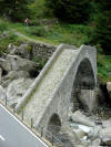 |
Medieval Bridge |
This is one of the ancient bridges
over the Reuss River in the
Schollenen Gorge. I didn't get a
picture of it, but the most famous
bridge in this gorge is the Devil's
Bridge (the
Teufelsbrücke).
It got the name from the legendary
events surrounding it's construction
in the middle ages, when a seemingly
insurmountable section of the gorge
prevented completion of the road.
The devil offered to finish the
bridge, at the cost of the first
soul to cross it. The crafty
townspeople made sure the first to
cross was a goat.... |
 |
Arrival at Lake Lucerne |
At the end of the day, we had
crossed the Alps, to finish our
travels at another glacially carved
lake on the northern flanks of the
range, Lake Lucerne. The weather was
overcast, cool, and even rainy. It
was a refreshing change! Mt.
Pilatus, our main destination on the
next day, dominated the skyline from
the north shore of the lake. |


