|
Normal Faults |
|
Normal faults are produced by
extensional stresses, which causes
the headwall of the fault to sink
against the footwall. Normal faults
are common in the Basin and Range
Province of the western United
States (eastern California, most of
Nevada and western Utah). |
 |
 |
 |
 |
 |
 |
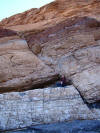
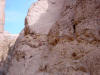
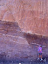
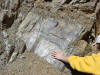
| Normal fault
in Mosaic Canyon, Death Valley. The
person's head is touching the
headwall, which has moved down
relative to the footwall |
Normal
fault in Mosaic Canyon, Death
Valley. |
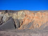
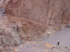
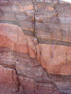
Normal fault
exposed in wall of Ubehebe crater, a
phreato-volcanic explosion pit in
northern Death Valley |
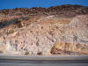
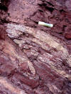
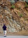
Normal fault
exposed in roadcut near Shoshone,
CA. The left side headwall is down
relative to the right (layers are
not connected to each other) |
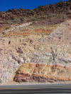
Normal
faults in roadcut near Shoshone, CA.
There are two faults at least. Can
you see them? |
Normal faults illustrated in
roadcut near Shoshone, CA (we call
it the "Charlie Brown outcrop) |
 |
 |
 |
 |
 |
 |
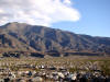
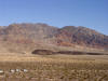
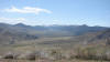
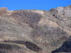
| Scarp and
triangular facets near Mormon Point,
Death Valley |
Mormon Point
is a turtleback fault, related to
detachment faults. A scarp runs
across the center of the picture |
Copper
Canyon turtleback. The dome-shaped
mountain is an upward warped fault
surface related to detachment
faulting |
Wineglass
canyon in Black Mountains of Death
Valley. |
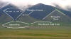
Illustrated
view of wineglass canyon: alluvial
fan makes the base, narrow lower
canyon the stem, and upper canyon
the cup. |
Small normal
offset in Proterozoic gneiss at
Death Valley |
 |
 |
 |
 |
 |
 |
| Two fault
scarps from relatively recent
earthquakes cross an alluvial fan at
Badwater, Death Valley |
Fault
scarps from relatively recent
earthquakes cross an alluvial fan at
Badwater, Death Valley(highest
resolution available) |
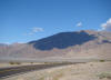
Scarp and
linear arrangement of basalt cones
indicates a normal fault zone in
Death Valley (highest resolution
available) |
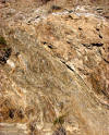
Fault gouge
surface on Badwater Turtleback
detachment fault near Natural
Bridge, Death Valley (highest
resolution available) |
Surface of
Badwater detachment fault near
Natural Bridge in Death Valley
(highest resolution available) |
Surface of
Badwater detachment fault near
Natural Bridge in Death Valley
(highest resolution available) |
 |
 |
 |
 |
 |
 |
| Scarp of the
1872 Lone Pine earthquake in the
Owens Valley of California. This
quake was close to magnitude 8 |
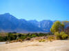
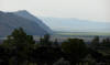
Large scale
scarp, the eastern escarpment of the
Sierra Nevada near Lone Pine (Mt.
Whitney near center of photo) |
Rangefront
fault at Calico Ghost Town in
California's Mojave Desert |
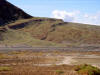
Triangular
facets, wineglass canyons and recent
scarps in Sangre de Cristo Range of
Colorado |
Illustrations of triangular facets,
wineglass canyons and recent scarps
in Sangre de Cristo Range of
Colorado |
Triangular
facets, wineglass canyons and recent
scarps in Sangre de Cristo Range of
Colorado |
 |
 |
 |
 |
 |
 |
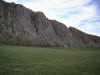
| Gillems
Bluff at Lava Beds National
Monument, a normal fault scarp.
Adjacent Tule Lake is a graben. |
Scarp from
geologically recent earthquakes,
Wheeler Crest of the Sierra Nevada
near Bishop CA |
Illustrated
scarp from geologically recent
earthquakes, Wheeler Crest near
Bishop CA |
Topaz Lake
and the Antelope Valley, CA/NV
border. This is a horst/graben
complex with an artificially filled
lake |
Fault scarp
at southern end of Antelope Valley,
eastern Sierra Nevada. Scarp
indicated by shadows on ridge. |
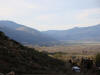
Horst
(range) and graben (fault valley) at
Antelope Valley in the the eastern
Sierra Nevada |
 |
 |
 |
 |
 |
 |
| "Bearclaw"
scarp at Meadowcliff in Antelope
Valley, CA. The cliffs are resistant
granitic rock |
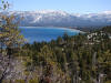
Lake Tahoe
is a natural fault graben lake
partially dammed by lava flows. |
Lake Tahoe
fills a fault graben on the edge of
the Sierra Nevada block |
Fairview
Peak fault scarp from
1954 earthquake in central
Nevada (Mag 7.1-7.3) |
Double fault
scarp and offset channel from
1954 earthquake in central
Nevada (Mag 7.1-7.3) |
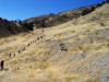
Teachers
climb up Fairview Peak fault scarp
from
1954 earthquake in central
Nevada (Mag 7.1-7.3) |
 |
 |
 |
 |
 |
 |
| Fairview
Peak fault scarp from
1954 earthquake in central
Nevada (Mag 7.1-7.3) |
Detail of
Fairview Peak fault scarp from
1954 earthquake in central
Nevada (Mag 7.1-7.3) |
Fairview
Peak fault scarp and extensional
trench from
1954 earthquake in central
Nevada (Mag 7.1-7.3) |
Detail of
Fairview Peak fault scarp from
1954 earthquake in central
Nevada (Mag 7.1-7.3) |
Fairview
Peak fault scarp from
1954 earthquake in central
Nevada (Mag 7.1-7.3). Note slope
break on ridge. |
Fairview
Peak fault scarp from
1954 earthquake in central
Nevada (Mag 7.1-7.3). Note slope
break on ridge |
 |
 |
 |
 |
 |
 |
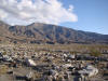
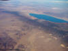
| Basin and
Range topography near Walker Lake,
Nevada. The mountain ranges are
called horsts, the valleys are
grabens |
A small
normal fault in Navajo Sandstone at
Zion National Park in Utah |
A roadcut
at the entrance to Arches National
Park in Utah exposes a normal fault
related to solution of salt beneath
the region |
A roadcut at
the entrance to Arches National Park
in Utah exposes a normal fault
related to solution of salt beneath
the region |
A roadcut at
the entrance to Arches National Park
in Utah exposes a normal fault
related to solution of salt beneath
the region |
A roadcut at
the entrance to Arches National Park
in Utah exposes a normal fault
related to solution of salt beneath
the region |
 |
|
|
|
|
|
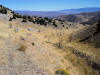
| Slinkard
Valley, a small active fault graben
in the eastern Sierra Nevada near
Monitor Pass, California |
|
|
|
|
|
|
|
|
Reverse and Thrust Faults |
|
Reverse and thrust faults are caused
by compressional stress, which
causes the headwall to be pushed up
and over the footwall. Thrust faults
have a fault plane that is inclined
less then 45 degrees from a
horizontal plane. Such faults are
especially prevalent in mountains
formed by continent-continent or
terrane-continent collisions. |
 |
 |
 |
 |
 |
 |
| A reverse
fault in Proterozoic rocks along the
Grinnell Glacier trail in Glacier
National Park |
Same picture
as previous, with fault and offset
layers outlined. The fault shows
drag folding. |
Another
view of fault along Grinnell Glacier
trail in Glacier National Park |
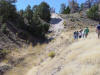
Examining a
thrust fault exposure in Sun Canyon,
Montana, south of Glacier National
Park |
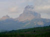
Chief
Mountain in Glacier National Park is
an overthrust. The cliffs were
pushed over the younger rocks below
and then isolated by erosion |
The Keystone
Thrust near Las Vegas, NV has pushed
the older gray limestone layers over
the younger yellow and red Mesozoic
layers |
 |
 |
 |
 |
 |
 |
| The Keystone
Thrust near Las Vegas, NV has pushed
the older gray limestone layers over
the younger yellow and red Mesozoic
layers |
High angle
fault separating Franciscan chert
from graywacke at the Presidio, San
Francisco, CA |
Headwall up
on section of Landers fault, Mojave
Desert. Movement was actually
lateral, but shifted a ridge,
forming a scarp. Details of the
1992 Landers Earthquake here |
Headwall up
on section of Landers fault, Mojave
Desert. Movement was actually
lateral, but shifted a ridge,
forming a scarp |
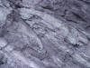
Slickensides
(striations and gouges caused by
fault motions) in San Antonio
Canyon, San Gabriel Mtns |
Ortigalita
fault in Del Puerto Canyon, Coast
Ranges, California. Sense of offset
not clear, could by normal or
reverse |
 |
 |
 |
 |
|
|
| Slickensides
exposed in Del Puerto Canyon in the
California Coast Ranges |
Slickensides
are the scratches and striations
left by fault motions. Upper Del
Puerto Canyon |
Reverse
fault in the Providence Mountains of
the Mojave National Scenic Preserve
of California |
Fault on the
Palms to Pines Highway, out of Palm
Desert, California |
|
|
| |
|
|
|
|
|
| |
|
|
|
|
|

