|
|
| Images of Hawai'i, the Big Island: the Active Volcanoes |

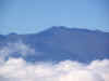
Mauna Loa from
the Mauna Kea
Summit Road
(photo by Garry
Hayes)
Hawai'i IS big,
in so many ways.
At more than
4,000 square
miles, it is
more than twice
as big as all
the other major
islands
combined. It has
the biggest
mountain and
biggest volcano
on the planet in
Mauna Loa. It
has arguably the
most active
volcano on the
planet. It has
possibly more
ecological
climate zones
than any similar
sized region in
the world,
ranging from
tropical
rainforest, to
desert, to
alpine
wilderness. It
has the largest
privately owned
cattle ranch in
the country. It
has some of the
purest air on
the planet,
ideal for
meteorological
and astronomical
studies. It is a
wonderful
outdoor
laboratory for
studying the
process of
evolution, and
unfortunately,
for studying the
effect of
invasive species
on a pristine
ecosystem.
The Big Island
consists of five
exposed
volcanoes (and
two submerged
ones). They are
Kohala (the
oldest),
Hualalai, Mauna
Kea, Mauna Loa,
and Kilauea.
Kilauea is
actively
erupting, and
Mauna Loa erupts
regularly every
few decades.
Hualalai erupted
200 years ago,
while Mauna Kea
and Kohala have
been quiet for
several thousand
years.
Our first four
days of
exploration
involved three
volcanoes:
Kilauea, Mauna
Loa and Mauna
Kea. We were
headquartered in
Hilo, the
rainiest town in
the United
States with an
average 120
inches per year.
For us
Californians,
the humidity and
the rainforests
were a strange
and alien
environment. But
also a beautiful
one...
| Arrival (click on photos for a better view) |
| |
|
|
 |
|
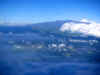
My inter-island flight to Hilo was nothing short of spectacular, providing a wonderful overview of the Big Island. I had a level eye view of the summit of Mauna Kea and it's collection of high profile research telescopes rising above the clouds. Those white patches are snowbanks. Although we would reach the 9,000 foot level on the volcano, our car rental agreement did not allow us to go all the way to the summit, so this view had to suffice |
 |
|
The volcano rises to 13,796 feet, and somehow doesn't seem so high, but those are tropical rainforests at the coast, and it is cold enough for snow on the summit! |
 |
|
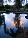
I arrived in Hilo a few days ahead of the students to do some recon, and to make sure everyone got picked up at the airport in time. We took some quiet time, which was easy, as the Hilo Hawaiian Hotel was surrounded by peaceful parklands. The serenity hid a violent past, though. These parks had once been the waterfront district of Hilo until buildings were swept away by tsunamis in 1946 and 1960, caused by quakes in Alaska. The hotel itself had an open parking structure and atrium designed to let future tsunamis pass under the building without doing catastrophic damage. |
 |
|
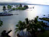
Hilo Bay from our hotel. The island in the foreground is Mokuola, or Coconut Island. Unfortunately Hilo Bay is shaped in just such a way as to funnel tsunami energy directly into the waterfront, and terrible damage has occurred here. Hilo is the main deepwater port on the island and is more of a working town than a tourist destination. It lies along the boundary between lavas from Mauna Loa and Mauna Kea, and has been threatened by lava flows in historic time, most recently in 1984, when the lava came within four miles of town. |
 |
|
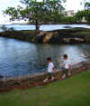
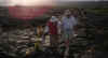
Nothing geological here, just a couple of cute kids wearing t-shirts that point to each other saying "he did it"... well, ok, there is a bit of a lava flow over there... |
 |
|
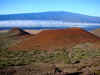
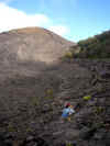
Hawaii is three hours later than the mainland, and with our jetlag, we were awake at 4:30 in the morning. Decided it might be fun to drive up the Mauna Kea Road. It was! Just after sunrise, we reached the 9,000 foot level with a wonderful view across the saddle to Mauna Loa, the massive shield that is the biggest mountain on the planet. The cinder cones in the foreground are related to the alkali basalt eruptions that covered the summit of Mauna Kea, giving it the steeper, lumpier aspect. |
 |
|
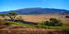
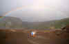
At the top of Saddle Road, which winds its way between the two massive shields, there is a tree-covered hill called Kipuka Pu'u Huluhulu that offers a short climb with a wonderful view from the top. The kipuka is an older cinder cone related to Mauna Kea's alkali basalt eruptions, but it is surrounded by recent flows from Mauna Loa (1935). The summit of Mauna Kea is higher and steeper than Mauna Loa, due to the more alkalic basalts, which tend to be more viscous and explosive than the basalts of the shield-building stage. |
 |
|
At the base of the kipuka I saw this linear feature that mystified me a bit; was it some sort of lava tube or something? It turns out it was a stone wall that was almost buried from both sides by the lava flow! |
 |
|
Mauna Kea is a spiritual place, and is considered by many to be a sacred realm of the gods. We were privileged in the quiet morning to see an offering made and to hear a beautiful chant. There are controversies over the uses made of the mountain and its summit area. Are the needs of scientist and rancher paramount over the spiritual needs and beliefs of the islanders? It is a difficult question that has not been dealt with well in the past. |
|
|
| Hawai'i Volcanoes National Park - Class begins! |
| |
|
|
 |
|
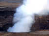
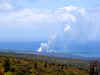
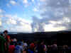
We spent most of the day on the 5th of June collecting students! I took not a single picture that day, but on the 6th, that changed a lot. We wasted no time driving the 30 miles from Hilo to the summit region of Kilauea in Hawaii Volcanoes National Park to see one of the two eruptions taking place on the island. We arrived to see the steam and gases pouring out of the vent in the Halemaumau crater. A sense of scale: the cliff behind the steam is 300 feet high, and the pit is about 300 feet across, the length of a football field! It started in late March 2008 with an explosion that left blocks of lava three feet across onto the adjacent parking lot and viewing area. Acrid gases make this a difficult problem with island air at times when the wind blows wrong. |
 |
|
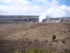
A more distant view reveals more of the setting. Like a Bushka Doll, the erupting pit lies within the Halemaumau Crater, which in turn lies within the caldera of Kilauea. The caldera is 2-3 miles across, and sits atop the Kilauea shield that reaches an elevation of just over 4,000 feet. The weather at that altitude is cool, and often rainy. These photos were taken from the observation deck of the Jagger Museum on the lip of the caldera. |
 |
|
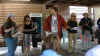
Lest anyone thinks I was on vacation, well, I lectured a lot...here was the first, at the Visitor Center for the park. |
 |
|
The class had their first view of the massive flank of Mauna Loa as the clouds briefly cleared... |
 |
|
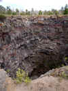
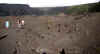
After taking in the steaming vent of Halemaumau, we made our way down Chain of Craters Road to look at some of Pele's handiwork over the last few decades. Major eruptions happened in the region numerous times in the late 1950's and 1960's, and again in the 1970's. We stopped at the Devil's Throat, a 160 foot deep pit that is one of the more unstable places in the park. |
 |
|
The Throat probably formed in the late 1800's and was once much larger. Notice how it once had an opening only a few yards across, and yet was much deeper than it is now. Debris has been falling off the edge and filling the pit. You can read the story of the crater here on the HVO site. |
 |
|
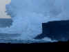
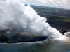
We starting winding down the pali (cliff) towards the coastal plain. Coming around the bend we had a first look at the ocean entry of the Pu'u O'o flow! A vast plume of steam was rising from the ocean where the lava was pouring into the water. We were about 10 miles away as the crow flies (crows in Hawaii, it should be pointed out, are extremely rare; there is a native species, but there are only about 2 dozen left, and all are in captivity for breeding). |
 |
|
What happened to the beautiful sunny clean air? The road passed through the plume from the Pu'u O'o vent and it was nasty stuff. Sulfurous fumes and acids made breathing very difficult for some of us. I can barely imagine what the acids are doing to the plants that can't move out of the way.... |
 |
|
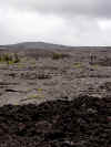
Another stop along the Chain of Craters Road brought us to the desolate landscape of the Mauna Ulu eruption which took place from 1969 to 1974. Three important features are visible in the photo: the shield of Mauna Ulu, where the flows emanated from; pahoehoe flows in the middle distance with their smooth surfaces; and a'a flows in the foreground, with their rough blocky appearance. |
 |
|
We drove back towards the park center. It was 1:30 or so, well after the lunch hour, so when we invaded the Volcano House diner, we took it over completely. Lots of people dine with an ocean view or a mountain view. How many of you have dined with a view of an erupting volcano? |
 |
|
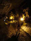
After a nice lunch we headed out again into the park with a hike through Thurston Lava Tube. The tube is part of the feeder system that fed lava flows many miles from the vent. As the flows ebbed, the tubes drained, leaving behind these fascinating caves. There is a cave in the immediate vicinity, Kazumura, that was recently found to extend for forty miles from the summit of Kilauea almost to the sea! That makes it the longest and deepest lava tube known anywhere in the world. |
 |
|
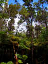
It seems strange, but only a few yards from the blasted barrens of the recent lava flows, a rain forest thrives in Hawaii Volcanoes National Park. The hike to and from the lava tube passes through a multi-tiered rain forest with a canopy of native O'hia trees, and a second level of tree ferns above the forest floor. More to come on those O'hia trees; they are a fascinating part of the landscape of the Hawaiian islands. |
 |
|
It was late in the afternoon, and time for an adventure! Kilauea Iki was the site of an intense eruption in 1959 that produced a new cinder cone (Pu'u Pau'i, "gushing hill"), the highest fountain of lava ever recorded in Hawai'i (1,900 feet; the Empire State Building is a trifling 1,270 feet), and a huge lava lake that took more than 30 years to solidify, and which is still steaming hot, as you will see. The solidified lava lake is in the foreground (do you see the contraction cracks along the edge?). The cinder cone is on the left in the distance. The eruption of Halemaumau continues in the far distance. Our four-mile trail would wind along the right side rim and drop 400 feet into the crater, then cross the barren lava lake, and then climb back up to the rim... |
 |
|
The trail initially wandered through a nearly pristine rain forest just feet from the abyss in places. Openings in the vegetation allowed peeks down into the crater. It was tempting to step through the ferns, but I noticed there were places were the plants hung over the edge of vertical precipices. |
 |
|
The trail dropped over two ledges and the rainforest was suddenly gone. We emerged onto the blasted landscape at the base of the Pu'u Pau'i cinder cone. Notice the slumps on the flank of the cone. I assume it was destabilized by the subsidence of the lava lake as it cooled over the decades. |
 |
|
We set off across the broken surface of the former lava lake. The interior stayed molten for more than 30 years, subsiding as the lava cooled and contracted. Even today, the solid rock still is cooling and shrinking around 3/4" a year. Look carefully in distance and you can see the occasional steam plume rising. Rain clouds were starting to gather on the east end of the crater... |
 |
|
The rainstorm began, but not without a colorful greeting! Then it got wet... |
 |
|
The increased humidity that accompanied the rainstorm caused the full extent of the hot rock to become visible. Steam was suddenly everywhere. |
 |
|
Maybe the strangest landscape of the day: the encroaching rainforest. Pioneer species of fern and O'hia trees gain a roothold at the eastern end of the crater. A 400 foot climb, a 30 mile drive and the first very full day was over! |
|
|
| The Coast north of Hilo, and the Puna District: Looking for Lava! |
| |
|
|
 |
|
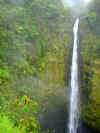
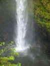
The next day was one of questions. We intended to see, if we could, the lava pouring into the sea near the former location of Kalapana. The problem is that the lava flows could be capricious and change without warning. Just days before our arrival, the lava did stop flowing for a time, but resumed. We would not be able to get to the lava viewing area until the evening, so we headed north of Hilo to check out some of the sights on the flanks of Mauna Kea. Our first stop was Akaka Falls, a 400 foot beauty. Who knew it could RAIN in a rainforest?? |
 |
|
One of those tropical paradise kind of places, hidden deep in a rainforest. The plateau up above had been a sugar cane growing area up until the 1990's. The economic future of the area is less clear now. |
 |
|
Our next stop was a dozen miles up the coast at the village of Laupahoehoe. The shoreline here is one of the most rugged and chaotic places I know of on the Big Island. The rocks are not normal basalt flows; they are instead mudflow deposits, made up of chunks of lava inches to feet across in a matrix of finer grained ash. The waves have eroded the rocks into a rugged puzzle of pinnacles and spikes. Swimming here would be suicidal! |
 |
|
I've never been here when the sea wasn't agitated. The waves crash against the rocks in a totally chaotic manner. No nice rollers here for the surfers. |
 |
|
There is an aura of intense sadness that permeates the beach area at Laupahoehoe. On April 1, 1946, a tsunami generated by a huge earthquake in Alaska struck the coasts of the Hawaiian Islands. Extreme damage was recorded in many places, but the town most affected must have been Laupahoehoe. A small school once stood near this memorial, and 24 students and teachers were swept away. It was a horrible blow to this small town. The victims are still remembered. The town was moved to the plateau high above the coastal flat in the aftermath. |
 |
|
After a long lunch break in Hilo, we set out towards the Puna District, on the easternmost tip of the island. It lies on the east rift zone of Kilauea, and is always under the threat of volcanic activity and earthquakes. In 1790, a small eruption overwhelmed a rainforest of O'hia trees. As the lava flowed against the trees, it froze while the rest of the lava continued to flow past. As the level of the flow subsided, the lava trees ended up as pinnacles. It took time for the trees to burn away, so the core of each pinnacle has a perfect mold of a tree. The early inhabitants of the islands thought these to be people turned to stone. This area is now protected as Lava Trees State Park |
 |
|
Not really geological, but the Lava Tree Forest has a canopy of beautiful trees called Mollucan Albizea. They are not a native species. In the 1920's, the rainforest around Hilo had been decimated by fires and other problems, so trees like the albizea were planted as an experiment. They did well in the environment and are gorgeous trees. |
 |
|
It was nearly 5:00! It was time to find the end of the road and hike to the lava viewing area. It turns out that GPS units are kind of useless in areas where lava flows have destroyed highways, so we had a false start, but we followed the carnival noises, parked, walked past the gauntlet of hawkers and barkers, and started walking across recent lava flows to the designated lava viewing area. |
 |
|
This was not a smooth, well-groomed trail! It was fresh lava! Access to the flowing lava was restricted for very valid safety concerns. There are circumstances at times when one can walk right up to the edge of an active flow, but they are kind of rare. Most of the time the lava is flowing underground in lava tubes with unstable roofs. At the ocean entry, vast amounts of steam charged with sulfurous acids and nasty shards of glass could actually kill someone just by breathing it in. The lava develops benches floored by loose debris which are subject to collapse (and these collapses have killed people in recent years; see pictures coming up from our helicopter flight...of the benches, not of dead people!). |
 |
|
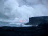
The lava viewing area is about 2,000 feet from the ocean entry. No one promises that we will see anything other than steam, and in daylight, steam is pretty much all you will see (this is not to say that it isn't very dramatic; it is!). This shot gives an idea of the scene. As you will see, a good zoom is a powerful photography tool! |
 |
|
I spent the first hour or so taking pictures like this one of the steam and the crashing waves, probably thirty or so, not realizing what was coming up... |
 |
|
As dusk deepened, things started to change. Either the growing darkness, or a change in the direction of the lava flow caused the steam cloud to start glowing orange. For split seconds, we could see lava dripping into the sea. We started snapping more pictures. |
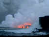 |
|
And there was the lava! A first view ever of flowing lava for many of our people. |
 |
|
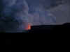
The fiery cauldrons of hell! In the growing darkness we gathered up the troops (as many as we could find) and headed back to the cars, on back down the road to the hotel.
|
|
|
| Into the Skies of Hawaii, One Way or Another! |
|
 |
|
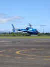
You can say what you want about it: too expensive, an extravagance, oh-so-touristy, but I have to say that nothing quite prepares you for a helicopter flight over an erupting volcano...we started the day with a disappointing car trip to Rainbow Falls in which I almost smashed our vehicle trying to go up the street that had only yesterday been a two-way highway, but which that morning was one-way for traffic control, with really small signs. And then the falls weren't really even flowing...but things got better after that! Gerry and the Wilkins are in the chopper taking off. |
 |
|
And off we go! That's the heliport at Hilo Airport. Copters sure take off more gently than planes.... |
 |
|
This was a "waterfalls and volcano" flight. The Hilo doesn't quite have the kind of waterfalls that helicopters hover near, like Kaua'i, but there are some beauties out there. I would love to see them from ground level sometime. Waterfalls don't exist on the Mauna Loa side of Hilo, as the new volcanic flows are highly fissured and water simply sinks into the ground. On Mauna Kea, soils have developed enough to seal off many of the fissures, so water flows well. It still seeps into the ground, and some streams don't quite always make it to the sea. |
 |
|
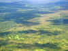
Flying from the waterfalls, we passed into the realm of Mauna Loa. A flow from 1984 briefly threatened the town of Hilo, coming to a stop only 4 miles away. The rainforest is beginning to reclaim parts of the flow. |
 |
|
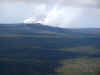
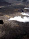
Flying south, the east rift zone of Kilauea and the cone of Pu'u O'o became visible. It is hard to see from the ground from any angle, so this was my first look at the volcano. Pu'u O'o is the source of many of the lava flows since 1983. It is currently degassing while it feeds lava into lava tube systems leading towards the sea. There is no visible lava within the cone, but conditions there must be positively hadean. It is only a fraction of its original height of 800 feet. |
 |
|
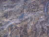
We flew closer to the cone, and started a circuit around the summit. Older lavas are shades of brown and red due to oxidation of iron in the rock. The youngest lavas appear silvery because they have a glassy coating of obsidian (more in a moment) |
 |
|
Very little lava is usually visible in the current eruption, as it spends most of the time in lava tubes before debouching into the sea. The path of the lava tubes is clear, however, due to a series of gas vents at intervals along the slope of the shield. The ocean entry we viewed the previous night is visible in the distance. |
 |
|
Little can be seen inside the crater, but this photo provides a nice perspective on the young pahoehoe flows on the flank of the cone, and a pretty good explanation for why the cone is shorter than it used to be: it is collapsing inward over time. |
 |
|
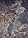
We started to follow the lava tube system down the slope towards the Pacific Ocean. At various time, lava breaks out of the tube system, forming a sort of mini-shield volcano. Because it is fed by a tube and not a normal vent, it is called a rootless shield. That's an older one at the lower middle of the picture exuding the steam. |
 |
|
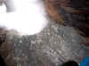
We then passed over one of the most ghastly landscapes I have ever seen. A series of breakouts had been occurring in recent weeks, with lava escaping from the tube system and spreading out over the upper part of the pali. Lava was flowing on the surface, and rapidly cooling into a series of globular masses of silvery pahoehoe lave. I was reminded of the imagery of J.R.R. Tolkien's Mt. Doom in the land of Mordor. |
 |
|
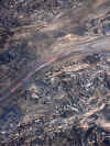
Two very recent breakouts and flows... |
 |
|
Lava was flowing in well-defined channels in places. It would have been quite a sight at night! |
 |
|
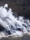
And then it was down to the coast for a look at the Waikupanaha ocean entry. It was one thing to stand and watch the clouds of steam rising and quite another to fly around it! I think this is the moment when most of the passengers were starting to get a little queasy (but not me, of course!). Some clouds don't seem substantial. I almost felt like I could step out and climb onto this one! |
 |
|
From the east end, one starts to sense the violence between lava and water with the discolored roiling water and multiple streams of gases rising. The latest lava benches can be seen on the lower left. There are only loose cinders underneath the benches, so they are subject to collapse at any time, including when tourists are standing on them. |
 |
|
There was a second tube system and ocean entry (the Kupapa'u entry) about a mile down the coast. It wasn't producing as much steam, so the lava flow was visible at times. |
 |
|
One last circuit around the Waikupanaha ocean entry, and we were headed back to Hilo. It was the shortest 45 minutes I can ever remember having. |
 |
|
I was snapping some random pictures on the way back and didn't realize I had captured the entire flow in one image. Pu'u O'o lies at the far right, the lava tubes and pali in the center, and the Waikupanaha ocean entry at the far left. The entire flow is about seven miles long. |
 |
|
What a day! The helicopter experience was enough for mere mortals, but we had lots more to do! After a lunch break in Hilo, we headed up Saddle Road, which passes between Mauna Loa and Mauna Kea on our way to the Onizuka Center for International Astronomy Visitor Information Station (record for a place name?) at the 9,300 foot level on the south flank of Mauna Kea. Once more we were reaching for the sky! We made a stop at Kaumana Cave, a three-mile long lava tube just outside Hilo, and we climbed Kipuka Pu'u Huluhulu (see pics above) before arriving at the station in the lengthening shadows of the evening. The evening was about astronomy! I climbed to the moonscape at the top of a nearby cinder cone to watch the sun set. |
 |
|
The view was striking. I was looking directly across the saddle towards Mauna Loa. The sun was highlighting a group of cinder cones related to Mauna Kea's alkali basalt eruptions. The haze creeping up the mountain is the plume of acid and sulfur dioxide from the eruptions at Kilauea. The vog threatened our viewing conditions at the astronomical center, but provided an otherworldly feel to the vista. |
 |
|
As the sun settled below the horizon, Mauna Kea cast an immense shadow on the far horizon. It had been a long day, but more was to come. There were telescopes set up and we had a great introduction to the night sky by the staff at the center. I saw the Southern Cross for only the second time, and we had great views through the telescopes of the rings of Saturn, and a globular cluster with thousands of visible stars. It was a great way to end our day, and to bid goodbye to Hilo. The next day we would be headed to the Kona Coast! |
|
|
|
|
|
|
|


